Ken so looks forward to his annual bike adventure with friends. They had planned to do France last year, but COVID shut them down. This year they made up for it with a10-day trip. They started in Pittsburg, PA on June 4, 2021, and ended up in Washington DC on June 13, for a total of 334 miles.
Ken will help tell about his adventure:
 |
Ken ready to ride his bike, wearing his GAP and C&O Towpath Trail biking jersey, which he bought online after returning from his trip.
|
 |
The back of Ken's GAP and C&O Towpath Trail biking Jersey, showing each of the towns along both paths and the mileage between Pittsburgh & Washington DC
|
 |
June 4: Pic of our group at Golden Triangle Bikes, our bike rental company in Pittsburgh, just before starting our ride. LtoR=Greg Last, Greg's granddaughter Halle Hawkins, Sydney Adamson, Ken Hinton, Whitney, Derena & Jeff Adamson, Tanner (Margret's grandson), Derena's Aunt Margret Lorren, and Margret's other grandson Henry Blalock. Each day, as we gathered to begin our ride, we would take a group picture and have a prayer together. The mouth for each prayer was rotated from youngest to oldest. I got to give one of our last prayers.
|
 |
Ken in front of the Golden Triangle Bike Shop's map of downtown Pittsburgh, pointing to our bike shop's location, which was also the starting point for our bike trip.
|
 |
| Ken's selfie as we reached Point Park in downtown Pittsburgh. Notice the rest of the group biking away from me in the background. |
 |
| Ken's selfie showing part of Point Park, with Whitney, Halle & Derena in the background. |
 |
| Ken's selfie at the "point" of Point State Park where the Monangahela & Allegheny Rivers converge. Notice the Allegheny River & the Pittsburgh Steeler's stadium in the background |
 |
Ken standing in front of the Point State Park fountain at the confluence of the Monangahela & Allegheny Rivers in Pittsburgh
|
 |
| Ken standing with the Pittsburgh Pirate's 2nd baseman legend, Bill Mazeroski statue alongside the Pirate's baseball stadium. The Pirates were Ken's favorite professional baseball team when he was young. They were his favorite because Vernon Law, a fellow member of the Church of Jesus Christ of Latter-day Saints, was one of their pitchers (Incidentally, Kay's dad was the Law's family physician.) Bill played second base for them during that time. |
 |
| Derena, Tanner, Margret & Henry in front of the Pittsburgh Pirate Baseball Team's Three-Rivers stadium, located at the edge of the Allegheny River in downtown Pittsburgh. |
 |
| Ken's selfie in front of a map of the North Shore of the Three River's Park, across the Allegheny River from the Pirate's Three-Rivers Stadium. |
 |
Whitney Adamson doing a walking handstand around the statue of Roberto Clemente, one of the Pittsburgh Pirate's legendary players.
|
 |
Whitney Adamson continuing her walking handstand around the statue of Roberto Clemente.
|
|
 |
| Ken's selfie in front of the Roberto Clemente statue, with Greg Last in the background. |
 |
| Ken's selfie in front of the statue of another Pittsburgh Pirate's legend, Willie Stargell. Each of these Pirate legends were stars on the team I cheered for when I was a youth. |
 |
| Ken's selfie in front of the statue of another Pittsburgh Pirate's legend, Honus Wagner. |
 |
Ken's selfie in front of a Point State Park map in downtown Pittsburgh.
 | Jeff got this picture of me as we were leaving downtown Pittsburgh on the GAP Trail. Jeff was our group's most prolific photographer. Sometimes, he would go ahead of the group, dismount and video or take pictures of each of us we rode by. Sometimes, he would pull his smart phone out while riding and just start taking pictures or videos of those ahead of him and behind him, while he continued to ride. Pretty amazing, right?
|
|
 |
| Jeff caught me traversing one of the bridges we crossed along the GAP Trail. This one crossed multiple railroad lines, instead of a river. It was located as we got into the more suburban areas of southeast Pittsburgh. |
 |
| Greg & I biking together. Although I spent most of my time biking alone at the back of our pack, we would all periodically pull up alongside one of our team and bike side-by-side so that we could visit with each other. This gave us wonderful social interaction time; however, it frequently caused other bikers we encountered along the trail to feel some animosity toward us. Especially on this first day, when we were biking a section of trail located in an urban area, there were lots of other bikers on the trail. Thus, socializing was probably not a great idea for us. As I was riding in the back, I noticed multiple bikers shaking their heads at us or, even worse, uttering unpleasantries at us. The problem was that the trail and towpath rules clearly called for only biking single file. We were definitely breaking that rule. What made matters worse is that many of us did not pay attention to oncoming traffic as we were chatting together; thus, we caused the other bikers to slow down. They definitely did NOT like being treated that way. I also had an unfortunate experience with this several days later, while on the C & O Towpath. On that day, a solo biker that I had noticed several times over the past few days caught up with us (again). As he passed me, I wished him well. He must have been feeling lonely because he slowed down to ride alongside me and chat. By this late stage in our ride, I had become very accustomed to watching for other approaching bikers, and so as we visited, I kept my eye open for other traffic. I noted a guy biking toward us, and so I slowed down so my new acquaintance could pull over in front of me and let the oncoming biker pass us without impeding him. The fellow that was talking to me was not paying attention though. Thus, he didn't see the oncoming guy until it was too late. It all happened so fast, and I kept thinking he would pull in front of me, but he didn't. The on-comer took the Lord's name in vain as he veered off the trail to avoid my fellow traveler. His bike wheels got caught in some thick grass and weeds, pulling his bike down. Luckily, the man fell onto the trail, instead of going the other way and getting into really big trouble in the canal. Fortunately, he was unhurt. I immediately stopped, hopped off my bike, tried to help him get up, and offered my sincerest apologies for my new friend's mistake. The fallen man quickly recovered and softened. He could see that neither he nor his bike was injured or damaged, and so he kindly said something like, "No problem" and rode off down the trail. I felt TERRIBLE and embarrassed. The offending biker pulled up alongside me again to continue talking with me, but I quickly and sensitively suggested that there was too much oncoming traffic for us to continue our riding two-abreast. He agreed and rode on ahead. |
 |
Looking from the GAP (Great Allegheny Passage) Trail across the railroad tracks and the Monongahela River at some of the iconic Pittsburgh steel mills that I have heard about all my life. Today we rode the GAP Trail from Pittsburgh to Belle Vernon, just beyond West Newton, for a total of about 45 miles. The hardest part was climbing a steep hill up and away from the Monangahela River at the end of the day. At that point, many of us were tired and worn out. We had to ride 2.3 miles from the trail so we could reach our hotel for the night--the Comfort Inn in Belle Vernon.
 | | June 5: Leaving the Comfort Inn in Belle Vernon to start our 2nd day of riding. On this day we rode about 28 miles from Belle Vernon to Connellsville, PA. It was a good, short ride to allow us to recover from the rigors of yesterday's ride. As we made our way back to the trail from the Comfort Inn, we experienced some unwanted stress and worry. We lost Sydney as she went ahead of the rest of our group to the trail. Others of our group, who had been biking near her, were SURE she had taken a wrong turn. After scouring the terrain (which included a steep, wicked hill), along the wrong turn's route twice, and conjuring up all kinds of bad things that MUST have happened to her, we finally made phone contact with her and found that she was safe and sound on the trail. All is well that ends well, correct? |
|
 |
June 5: A look upriver from a GAP bike path bridge over the Youghiogheny (pronounced YockaGAINy) River. The locals simply referred to the river as "The Yaw". The GAP Trail ran alongside this large river for many miles in Pennsylvania. For long distances along the GAP Trail, after we left downtown Pittsburgh and biked alongside the Monongahela and Youghiogheny Rivers, there were lots of blooming honeysuckle plants that made the air rife with their sweet redolence. I breathed it all in as best I could, reveling in the appealing fragrance.
 | Ken & Jeff checking out a point of interest. Along the trail, there were periodic points of interest. We frequently would stop at those sites to check them out. This one was a boardwalk that had recently been built on an old railroad bridge. It went out about half way across the Youghiogheny River. It afforded a different perspective of the river, looking both up and down stream. While we were there, various groups floated by on the river below us. One group got brave, paddled to the shore, climbed up to the boardwalk and jumped off into the river. It looked both refreshing on a hot day, but also rather foolish, because we could see that there were many places in that area of the river that were way too shallow for such jumping.
|
|
 |
Following the Adamson Family into the park adjacent to our Comfort Inn in Connellsville, PA. That day and evening the community was holding a festival/fair. As you can see, they had numerous booths, most of which were food-related. They also had a fishing derby, a live band, an "anything-that-floats-except-a-boat" race down the adjacent Youghiogheny River. The ambiance was fun and festive. Alcoholic drinks were served from many of the booths and the locals were imbibing plentifully. It was intriguing for me to stand in the midst of it all drinking in the local culture (not the alcohol). I enjoyed that insight into the locals' lifestyle.
|
 |
I enjoyed the silent beauty of this sunset over the Youghiogheny River, while the town's festival was going noisily on all around me.
 | June 6: Group photo just before saying our group prayer & hitting the trail. We rode about 30 miles on this day, from Connellsville to Confluence, PA. LtoR: Halle, Greg, Sydney, Jeff, Whitney, Derena, Margret, Ken, Tanner & Henry.
|
|
 |
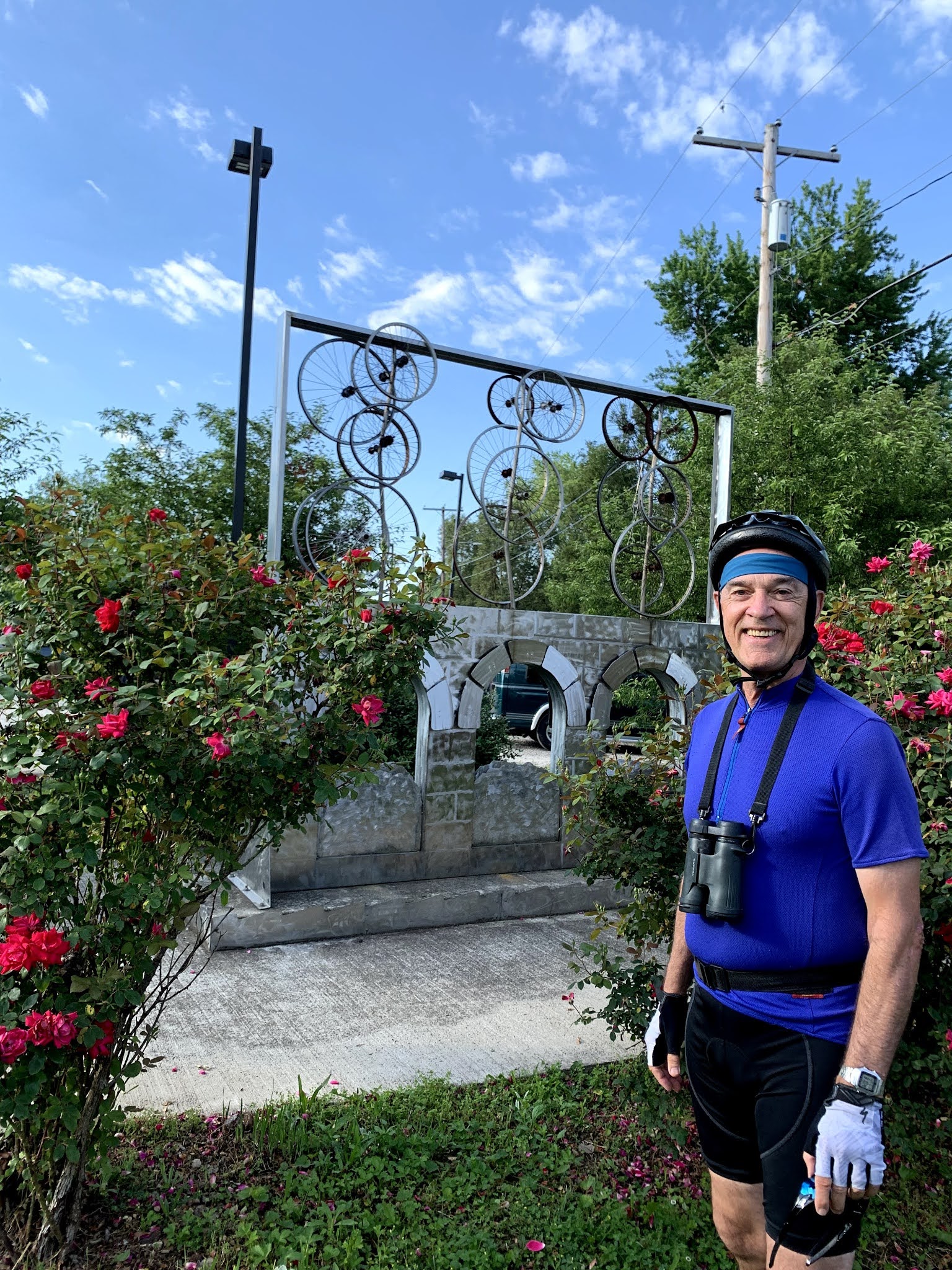
| Ready to start day 3 of our bike ride. Ken standing in front of a piece of biking artwork, which was located in front of our Connellsville, PA Comfort Inn. |
 |
| Ken's selfie of one of our numerous daily rest stops along the trail. LtoR=Ken, Jeff Adamson, Greg Last, Halle Hawkins, Derena Adamson, Sydney Adamson & Margret Lorren. |
 |
| Ken's selfie of one of our numerous daily rest stops along the trail. LtoR=Ken, Henry, Margret, Derena, Jeff, Whitney & Derena Adamson and Halle Hawkins. |
 |
| Crossing one of the many bridges along the GAP Trail. LtoR= Margret, Henry & Greg. |
 |
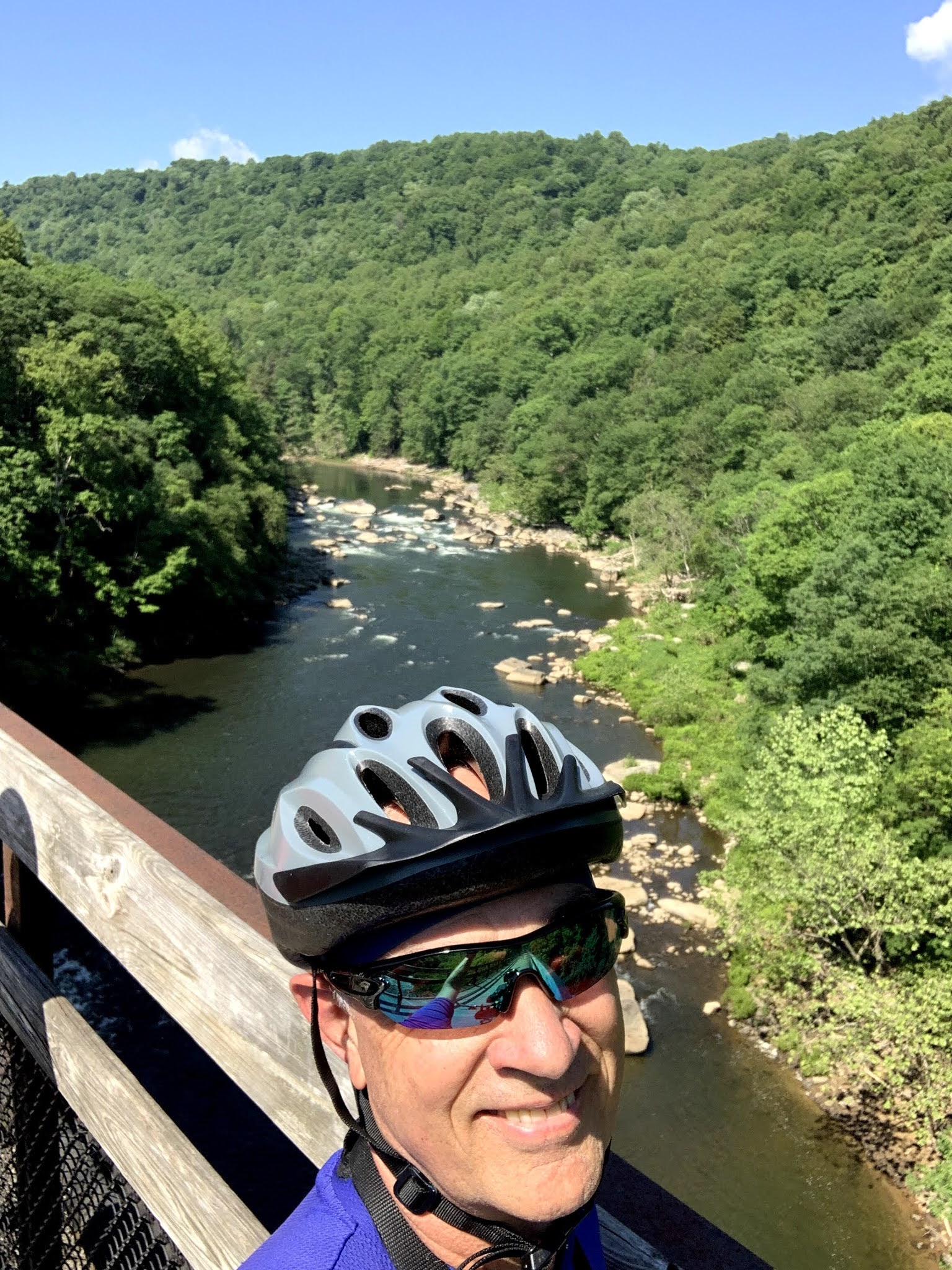
Ken's selfie looking over the bridge into the Youghiogheny River below.
|
 |
A rest stop along the trail. Left to Right: Margret, Henry, Ken & Sydney.

Same rest stop, taken from another person's camera.
|
 |
Ken and his rental bike on the bridge over the Youghiogheny River. We were told that Youghiogheny was an American Indian word that means "flows backwards", because this river flows northward.
 | Left to Right: Greg, Whitney, Sydney & Ken
|
This is how we rode for most of the way along the trail--in a group. LtoR: Whitney, Sydney, Halle, Ken & Greg.
|
 |
| My first sight of "Falling Water", the architect of which was Frank Lloyd Wright. An incredible structure. We stopped our bike ride for a couple of hours, leaving our bikes with our tour guide company in Ohiopyle, PA. We then took a van ride into the mountains above Ohiopyle for about 5 miles to this amazing place. Frank Lloyd Wright created this residence for a Pittsburgh retail magnate, whose name I cannot remember. |
 |
| Another part of Falling Water. This home was budgeted to cost about $50,000 to build, but ended up exceeding that amount just like usually happens these days in construction projects. I read that the final cost of the project was about $150,000. Now days, that amount wouldn't hardly build a servant's quarters for a mansion like this. |
 |
| Another part of Falling Water |
 |
| Another part of Falling Water, with Henry & Tanner (cousins) checking it out with me. |
 |
| Another part of Falling Water, with Derena checking out the unique water fountain. |
 |
| Another part of Falling Water |
 |
| Another part of Falling Water |
 |
| Another part of Falling Water |
 |
| A plaque at Falling Water |
 |
| Another part of Falling Water--the swimming pool alongside the upper structure. |
 |
| A different view of Falling Water |
 |
| Ken's selfie giving a different view of Falling Water |
 |
| Ken in front of the iconic view of Falling Water |
 |
| The iconic view of Falling Water, from a distance |
 |
| The iconic view of Falling Water, a close-up perspective. |
 |
A bird's-eye view of Falling Water
 | June 7: We are gathered together just up the street from our prior night's lodging, the Shoreline Bed & Breakfast in Confluence. It was a nice place for our group. We took the entire upstairs. All but Jeff & Derena had their own bedroom. Jeff & Derena slept on a pull-out sofa in the common living area. The home was nice and well maintained. The evening before, we ate dinner at a fine dining restaurant located practically next-door to our B&B, called the River's Edge Cafe. The food and service were excellent. At this point, we have just enjoyed a yummy breakfast in a "gas station cafe" in Confluence, and we are gathered for our morning prayer before beginning our day's ride. Today we rode about 33 miles from Confluence to Meyersdale, PA.
|
|
 |
| Back on the GAP Trail again, with our group crossing another of the many bridges. |
 |
| June 7: Picture of an appropriate saying that was hanging on a wall in the "gas station restaurant" in Confluence, where we ate breakfast before hitting the trail. As I considered Luciano's bit of wisdom, I couldn't help but think of Kay. I was sure she would appreciate his words of wisdom and so I took this pic and texted it to her. In Confluence, we stayed at the Shoreline Bed & Breakfast, which suited us well. The night of our arrival we ate at a very nice restaurant called River's Edge Cafe. The food was delicious. |
 |
| Jeff and others of our group enjoying the view from one of the higher & longer bridges over the Youghiogheny River, between Confluence and Meyersdale, PA. |
 |
| Ken's selfie from a bridge looking down into the Youghiogheny River. On this day 4 of our ride we covered about 33 miles. It was another incredible ride through the forest and hills of the Allegheny Mountains of Pennsylvania, along the banks of this picturesque river. |
 |
| Ken's selfie on another bridge, where we took another rest stop to relax and take in the awesome view. Ken, Greg & Halle are in the foreground. |
 |
| Ken & Halle in front of one of the many short tunnels we encountered on the GAP Trail. |
 |
| A shot from inside the tunnel. |
 |
| Margret (right) and Derena starting across the longest & highest bridge of our ride on the trails, just before reaching Meyersdale, PA. |
 |
| The view along the highest & longest bridge of the GAP Trail. It was about at this time that Howard Stucki called me and we had a fun chat on the phone. |
 |
| The view upriver from the bridge. |
 |
| Ken's selfie as we arrived at the Meyersdale trailside museum and gift shop. LtoR=Ken, Margret, Derena, Tanner, Henry & Jeff. |
 |
| I couldn't resist taking a picture of this incredibly beautiful blooming Rhododendron. After checking into our quarters for the night, the Yoder's Guest House, I wandered around town exploring and hunting for the best ice cream store. I found a soft ice cream shop that served me a yummy chocolate dipped ice cream cone. Although very tasty, the warmth of the evening made polite consumption of the morsel impossible. I had to lick and slurp as fast as I could to keep up with the melting treat. Yum yum! |
 |
| While exploring Meyersdale that evening, I found multiple old churches and homes with interesting & historic architecture. I called Kay as I wandered the streets and enjoyed my daily visit with her on the phone. During our conversation, it started to rain and so I took refuge in a small downtown park pavilion. Fun memories! |
 |
Another of the picturesque Meyersdale, PA churches.
 | June 8: A close-up photo of our group on the front steps of the Yoder's Guest House. LtoR: Greg, Halle, Ken, Derena, Margret, Whitney, Tanner, Sydney, Henry, Scott, Jeff, Joyce & Cindy. Sometime during the night, Scott & Joyce Seegmiller, along with their friend, Cindy Evans, arrived to join us for the rest of our bike ride.

This is the same picture as above, but this one gives us a better look at the beautiful guest house we had the privilege to stay in last night and within which we enjoyed breakfast this morning. Both the house and its outside grounds were very well kept. I especially loved the gorgeous Tuberous Begonias in the pots beside the front door. |
|
 |
June 8: Getting started on our 5th day of riding. This well-restored mansion/bed & breakfast was worthy of a picture. It was located a few blocks up the street from our guest house. I had checked on staying at this home, but found it to be too pricey. Our group, LtoR, is Halle, Greg, Henry, Tanner, Whitney, Sydney, Cindy, Derena & Margret. During the middle of the previous night, Scott & Joyce Seegmiller and their friend, Cindy, joined up with our group for the rest of our ride into Washington DC. They made our group 13 strong.

I was reading one of the many historic markers along the path. The rest of the group generally was ready to move on before I was done studying the marker, just as shown in this picture. |
 |
| Ken's selfie in front of the Eastern Continental Divide Tunnel. On this day of the ride, we rode about 45 miles. Cindy is in the pink jersey behind me. |
 |
| Ken's selfie in front of the Eastern Continental Divide Tunnel. |
 |
| Ken's selfie in front of the Eastern Continental Divide Tunnel. |
 |
| From Meyersdale to the continental divide, the grade was a gradual uphill, much like we had experienced for the entire ride so far. Once we got on the other side of the continental divide tunnel, the descent became rather steep, as shown in this graphic that was in the Eastern Continental Divide Tunnel. We lost a lot of elevation from the tunnel down to Cumberland, Maryland. |
 |
| Ken's selfie in front of the "Big Savage Tunnel". |
 |
| The view of the Allegheny Mountains and dells looking to the southeast, just south of the Eastern Continental Divide Tunnel. A stunning view. This is the direction the GAP trail took us. |
 |
| Ken's selfie in front of the Mason & Dixon Line monument. Shortly after leaving the Eastern Continental Divide Tunnel we happened upon this--the Mason & Dixon Line. I was immediately interested. I have heard about this line all my life; however, all I remembered was that it was a line that separated the northern states from the southern states. |
 |
| I learned so much from these historical interpretive markers. Charles Mason, an astronomer, and Jedediah Dixon, a surveyor, were sent to this region of America by the King of England to resolve a dispute between two powerful English families that held massive amounts of land in the area. They were the Penn Family on the north (Pennsylvania is named after them) and the Calvert Family on the south. Those two families were both claiming some of the same land near the current boundary between the states of Pennsylvania and Maryland. When Mason & Dixon were finished with their work, they solved the dispute by creating the Mason & Dixon Line, which currently serves a part of the boundary between Pennsylvania & Maryland. Ironically, those two powerful families lost all their land holdings within a decade later because of the American Revolution. |
 |
| Mason & Dixon had quite a company helping them in their endeavor, including quite a number of people and wagonloads of supplies. They used a 66-foot-long chain, similar to the one pictured above, to do their work. Can you imagine how many times they had to stretch that 66-foot chain in order to complete their surveying work that covered many, many miles through forested hills and dells? I was both impressed and amazed! |
 |
| This is the back side of the Mason & Dixon Line Marker, showing the names of the two English families involved in the dispute, and which state their land ended up in after the Revolutionary War. |
 |
| Ken riding into another of the many tunnels we passed through on the GAP Trail. I am waving to Jeff Adamson, who I knew was taking the picture. Just like this one, many of the tunnels were named, and had the year they were created recorded with their name above the tunnel entrances. Thus, you can see that the railroad line upon which the GAP Trail now runs, was originally constructed in the year 1911. |
 |
| Ken and our group seated at the Crabby Pig Restaurant, which was located in downtown Cumberland, Maryland, right along the trail. The waitress was taking our orders. LtoR=Joyce Seegmiller, Tanner, Margret Lorren, Henry, Scott Seegmiller, Whitney Adamson, Greg Last, Derena Adamson, Halle Hawkins, Sydney Adamson (hidden behind me) and Jeff Adamson. Taking the picture was Cindy Evans, the Seegmiller's friend. |
 |
| For months before our ride, I had been reading in the news about how this year was the summer the "17-year Cicadas" would all emerge. The news articles warned that there would be untold swarms of these cicadas (the term is "Semi" in Japanese) throughout most of the region we were planning to ride. The articles warned of an impending cacophony of noise that would be caused by the hoards of these interesting little creatures. This cicada was one of many that either landed on me or crawled up to or on me. |
 |
Although this little guy visited me near the Crabby Pig Restaurant, I did NOT eat him. Evidently some people DO eat them. The news articles warned that people with allergic reactions to seafood shouldn't eat them. I witnessed multiple birds trying to catch them for their own meal. Many members of our group, especially the girls and ladies, were less than enamored by these bugs. I would periodically see one of the women suddenly go into a frenzy when they realized a cicada was buzzing them or had landed on them. The first several days of our bike ride, I don't recall hearing or seeing any of these little creatures; however, at about Meyersdale forward we began to see and hear the hoards and their buzzing/humming sound emanating from the trees and bushes all around us, both in towns and throughout the forest as we rode along.
|
 |
Ken's selfie in front of the Crabby Pig Restaurant's front sign. Unfortunately, the Comfort Inn at which I had made reservations for us for that night was about 6 miles from the trail. In order to ride there, we would have had to do so on very busy roads and would have had to negotiate some difficult inclines. We were stymied for a while, trying to figure out how to safely get to and from the hotel. Then Jeff came up with the illegal, but still ingenious idea of renting a U-haul truck to get us and our bikes back and forth. Jeff & I rode our bikes to the nearby U-haul rental place while everyone else stayed at the Crabby Pig, and then we ferried our bikes and friends to the hotel in two trips. As we were conveying the group members, we passed a highway patrolman on the freeway. He pulled in behind us for a ways. We were worried he might pull us over and then we would be in trouble. Fortunately, he didn't do that. We got our bikes and all our people to and from the hotel without any negative incident.
|
 |
June 9: Our first day on the C & O Canal Towpath. The team had their group prayer & picture at the Comfort Inn as they left, while I was watching the bikes at trailside in Cumberland, waiting for their arrival. On this day we traveled just over 63 miles, from Cumberland to Hancock, Maryland. It was a long, long day on the trail. Another rest, relaxation and social stop along our way. The towpath was generally in much poorer condition than the GAP Trail was. The GAP Trail was always plenty wide and very well maintained, but the towpath varied greatly in its condition. At times, it was simply a rather overgrown single track. In other places, it was a dual-track with vegetation between the tracks. In some places it was wide and relatively smooth, such as you can see in this picture. You will note the green & white plastic bag I have put over my bike bag, behind me in the pic. I did this on the two or three days that the forecast called for precipitation. On this particular day, my efforts were wasted; however, on our second-to-the-last day, my efforts were VERY beneficial. Much of the towpath had received rain just previous to our traversing it. Thus, it seemed I was frequently trying to dodge mud puddles in the trail and avoiding the muddiest portions of the trail. For much of the way, the towpath was also relatively narrow, with rather precipitous drop-offs on one or both sides of the trail down to the Potomac River and into the remnants of the C & O Canal. I wasn't able to look off into the forest as much on this path for fear of crashing or veering off the trail and getting myself in trouble. LtoR=Ken, Halle, Greg, Joyce, Henry & Tanner.
Catching a drink from my Heinz Water Bottle that I purchased from our bike rental shop in Pittsburgh, Golden Triangle Bicycles. As it turned out, I was very glad I purchased this water bottle. I was surprised by how few and far between the culinary water sources were. If I hadn't bought this second water bottle, there would have been many times I would have run short on water along the trail. Our two young stallions, Henry & Tanner, needed plenty of water. In the mid-afternoon of our second day, I rode up to the main group, who were taking a rest and having a pow-wow. I was quickly made aware that the boys were either VERY low on water or were clear out. It was a hot afternoon and so we were all very concerned, knowing how scarce the water sources had been that far on the trail. As we were discussing our options, suddenly Greg realized that he didn't have his wallet. A mile or two back, we had stopped for a rest and Greg had pulled his wallet from where he normally carried it and placed it on the ground next to him as he made a phone call. His call was to arrange reservations for a van ride to Falling Water from Ohiopyle, PA tomorrow. He had forgotten about the wallet and left it on the ground at the side of the trail. Jeff and Greg made a quick trip back down the trail. We were blessed that it hadn't been picked up. Greg recovered it without further problems. As to the lack of water, we were again blessed, as we encountered a water pump in a trailside park a few miles further down the trail. We all filled our water bottles there and drank to our hearts' content. We learned our lesson that day regarding water supplies. We didn't have a problem with that issue the rest of our ride.

Greg, Halle & I, checking out one of the approximate 75 locks along the C & O Towpath. Notice the home of the person/family that tended to the needs at that lock (back in the day that the canal was functioning) in the background.
|
 |
| Group photo at the north entrance of the Paw Paw Tunnel. |
 |
Just arrived at the entry to the Paw Paw Tunnel. It is by far the longest tunnel on either trail, at about 1,300 feet in length. It is a bit of an adventure to traverse. The entire interior of the tunnel is lined with bricks. Most of the tunnel's width is taken up by the canal, but there is 3 to 4 feet of width dedicated to the towpath. It is both quite cool and VERY dark in there. Fortunately, our bike rental company gave us each a headlight we could use for just such an occasion. Needless to say, I walked my bike through the tunnel, rather than riding it. On this day I biked over 63 miles, but the 1300 foot-long walk through the tunnel caused my knees more pain than the entire day's ride. Gratefully, someone had installed a safety rail between the trail and the canal. Greg had read somewhere that we would have to detour around the tunnel; however, we were able to stay on the trail without a detour. On the other side of the tunnel, we did see signs saying the trail was closed, but we were still able to traverse it. There was a landslide that had blocked part of the canal, on its far side. Perhaps they felt like the sides of the mountain on either side of the trail was too unstable and so wanted to discourage people from passing by that area. LtoR=Ken, Joyce, Scott, Cindy, Margret, Tanner, Greg, Derena & Halle.
|
 |
Midway through our day's ride, we stopped at the ONLY place for refreshment between Cumberland & Hancock along the trail--Bill's Place. This establishment has been in business for decades, and although it is a "hole-in-the-wall" sort of place now, it has apparently seen some prosperous times in the past. Over the years, many patrons have left signed $1 bills attached to the ceiling and walls. It helped to create quite a unique ambiance. It used to be a full-service restaurant; however, on the day we were there, there was no cook. Thus, we were relegated to ice cream treats and cold drinks. That worked just fine for me because it allowed me a decent potty break also. I bought and consumed an ice cream bar and a pint of Gatorade while getting better acquainted with a couple of distant relatives, Margie Hinton and her son, Brian Hinton, who we had met earlier in the day at a rest stop along the trail. I'll tell a little more about them tomorrow. Although some days were worse than others, many times there weren't frequent enough places to use the restroom or to refill our water bottles. We quickly learned to watch carefully for such opportunities and to take advantage of them. It turned out just fine once we started doing that.
Our safe arrival at Hancock, MD. Since we knew this ride was going to be 60+ miles, Margret & Whitney took an Uber ride to Hancock and met us with a ribbon cutting and other celebratory activities as we arrived. LtoR: Sydney, Greg, Derena, Halle, Tanner, Henry, Joyce, Scott, Cindy & me. After this photo shoot, we biked to our hotel for the night, a Super 8. It was about a mile off the trail and was our only accessible lodging in the area for our group. Upon arriving there, Jeff took charge of washing the mud off all of our bikes. We ended up eating dinner in two groups this night. The Adamson's and their relatives ate at a nearby pizza place, while the rest of us walked into town and ate at a nice restaurant. As we neared the restaurant, we started to cross the main street. Cindy went first, followed by Joyce. It just so happened that they were in the shadows as they stepped out into the street. After a few steps, they reached the sunlight from the setting sun. The driver of a car approaching us, headed into the sun, saw Cindy and let her cross. He then accelerated forward, not realizing that Joyce was stepping out into the street right in front of him. We all yelled, and Joyce deftly stepped back just in time to avoid being run over. It was a VERY close call. Unfortunately for us, the restaurant host forgot about us and so we waited in the shade on the deck for about an hour and a half before we got our food. While we waited, a Pileated Woodpecker stopped by briefly. Our waitress granted us all a free first-helping of a drink because of their mistake, although they never actually admitted that they had forgotten us. Although late, the food was very delicious.
 It had rained the night before along much of the trail we rode on today between Cumberland and Hancock, MD. Some of us were more careful to avoid the mud puddles and muck along the trail. This picture was intended to document just how muddy the backs of some of our group had become today. Little did we know at the time just how much muddier and muckier we were ALL going to be in two days from now.
June 10: On this day we biked 28 miles from Hancock to Williamsport, MD, where we stayed in a Red Roof Inn. This is our start-of-the-day group photo in front of the Hancock, MD Super 8 Motel. Cicadas were swarming everywhere around and upon us, but they were especially plentiful in the trees behind us in the photo. |
 |
| Along the way, we left the towpath to visit this historic structure, Fort Frederick. It was originally built for the French & Indian War, but was also used in the Revolutionary War and the Civil War. We were fortunate to have a local volunteer at the fort during our visit. He got all dressed up in his wool colonial period attire (despite the fact that it was uncomfortably hot and humid for us, especially when we were in the sun.). He instructed us about the fort's history, his attire, and the musket that he fired for us. |
 |
| Ken and his colonial soldier friend. |
 |
This selfie was taken from outside the fort. It was just too big to be able to fully capture in one picture. Inside the fort, they had reconstructed two large dormitory-like living structures, and had furnished them with supplies, furniture, etc. that would have been common back in the day the fort was actively used for battle. Although rain was forecasted for this day and the clouds were gathering while we were visiting the fort, we made it safely to our Red Roof Inn before the rains descended. Those on the trail later than us, got drenched. We escaped that fate today, but it was a TOTALLY different story the next day.

A rest stop at one of the dam sites along the Potomac River. I am on the right, standing with my back to the camera.

A wide angle view of the dam and corresponding reservoir, referred to in the caption of the above photo.
 | | June 11: Group shot in front of Williamsport's Red Roof Inn just before we had our usual morning group prayer and hopped on our bikes to ride in the rain. LtoR: Joyce, Scott, Cindy, Greg, Halle, Ken, Whitney, Derena, Sydney, Margret, Henry & Tanner. Jeff took the photo. Today we rode just over 41 miles between Williamsport and Harper's Ferry. |
|
 |
Today was our most unpleasant day of the entire 9-day ride. It had rained during the night, and so we started our ride today on wet surfaces, although it wasn't raining when we hit the trail. That changed way too quickly. It began to rain before long, and continued unabated for the entire rest of the day. Much of the day, the rain came down with serious intent, creating a flood watch that we knew nothing about until we got safely tucked away in our Quality Inn rooms in Harper's Ferry, late that afternoon. By mid-day I started noticing that the water in most creeks the trail crossed were running rather high and fast. Then we happened on this creek crossing. Fortunately for us, we got across this bridge before the water rose enough to wash it out, but it was a little worrisome as we approached and crossed this tenuous structure. Halle's bike had suffered a flat tire a few yards beyond this bridge. Fortunately, Cindy witnessed Halle's plight and stopped to wait with her for Greg, Jeff and I to arrive. The main contingent pedaled soddenly forward, apparently oblivious to Halle's situation. We 3 men had been detained earlier and were hurrying to catch up with the rest of our group. Jeff, who is our designated bike repairman on our rides, made quick work of replacing the flattened tube. However, we noticed the Halle's other tire was rather low also. We aired it up a time or two as we made our way to Harper's Ferry, but it also gave up the ghost just as we entered the town. Jeff once again worked his magic for the repair while we all waited patiently again in the constant rain. The next day, early into our ride we came upon another, similar bridge that had both of its approaches washed away by the flooding. We were very lucky that our plans called for us to stop for the night before reaching that washed out bridge. When we arrived the next day, the water level had receded and someone ahead of us had created rough but usable repairs to the bridge's approaches. While riding the C & O Towpath, we frequently had muddy places in the trail. Many times the mud puddles and mucky spots were way too frequent. I would watch for such spots and try to pick the least wet, muddy or mucky place to ride my bike through. Many times I would ride the bike slightly off the towpath's gravel surface onto the adjoining grass & weeds in an effort to keep me and my bike as clean as possible. I started this day's ride the same way, but that only lasted a few miles before I realized my efforts to stay clean and dry were fruitless on this day. From then on I just plowed straight through the mud puddles, and muddy/mucky mires. Before long, enough rain had fallen that it seemed almost the entire trail was one long, muddy, wet mess. The closer we got to Harper's Ferry, our destination for the day, the more fallen trees and roiling water we saw cascading down hillsides, over roads, etc. When I arrived at the Quality Inn, rather than check in as I normally would, I asked for their water tap and hose. Despite the fact that it was still raining steadily, we all took our bikes to that side of the parking lot and I hosed down everyone's paniers, legs, backs, and bikes. We were all a muddy, wet mess. It felt really good to finally check in to the hotel, get a nice warm shower, and change into dry clothes.
 June 12: Group photo in front of our night's lodging, Quality Inn in Harper's Ferry. After this photo and our morning's group prayer, we began our longest day's ride of the trip--66 miles, to Washington DC.
Picture of the bridge we used to cross the Potomac into and out of Harper's Ferry. |
 |
| Today we rode from Harper's Ferry, West Virginia to Washington DC. The weather was great. Although the towpath was still wet and a bit muddy, most of the trail surface appeared to be a nice crushed aggregate, which made for excellent biking. It was cool & cloudy most of the day. Thus we had perfect weather to complete our bicycle journey. Notice in back of our biking group, there is another group. It turned out to be Margie Hinton's biking team. Thus, I asked she and her son over for a quick picture together to memorialize our meeting. That picture is below. |
 |
| Left to Right: Ken, Margie & Brian Hinton. Taken at the southern point of Harper's Ferry, looking downstream at the Potomac River. She is of Japanese descent (nisei or sansei). Brian is Margie's son. He was riding the trail with his wife. They appeared to be newlyweds. They were all riding with some of Margie's friends from San Diego, CA. Margie had married a Hinton from the east coast. They live in Virginia. Judging from my discussion with Margie, I think we'd have to go clear back to England to connect our ancestral lines. |
 |
Ken's selfie taken from the same place as the above two pictures, looking from Harper's Ferry down the Potomac River, at the confluence of the Shenandoah & Potomac Rivers. The Appalachian Trail goes right by where I was standing, and down the towpath trail alongside the river's left edge in the picture above, for several miles. In fact, we had a number of people hiking that trail who stayed in our hotel last night.

As we left Harper's Ferry, we had an unusual obstacle. We had to cross the Potomac River from Harper's Ferry to the C & O Towpath on an old railroad bridge (shown in a couple of different pictures above). Then we had to negotiate these metal stairs from the bridge down to the towpath level. This is Scott Seegmiller & myself hauling the bikes of some of the ladies in our group down the stairs from the bridge. This was not as difficult a task as we had hauling the bikes UP these stairs yesterday. Our fully loaded bikes were heavy enough that I could barely get them up the stairs without them breaking loose from me.
 | | The bottom section of the stairs down from the bridge. |
|
 |
This is the bridge that got washed out the day before. Notice that someone has gathered driftwood and placed it at the ends of the bridge to allow better bike access onto and off from the bridge. The rest of my biking friends are negotiating the far side of the bridge. You will note that I am wearing my glasses today, instead of my usual sunglasses. The cloudy weather made the day dark enough that I determined it was better to wear my glasses, at least for the first part of the day.
 | This was a common view for me, especially during the miles that our group members were biking close together. For 98% of the ride, I took the caboose position, making sure we didn't leave someone, especially one of our women, behind. There were a few times (e.g. when I stopped for a potty break while everyone else pedaled on) that I was ALL alone in the forest. At those times I was reminded of the importance of my sweeper position. If I was feeling alone and anxious, I could just imagine what it would be like for one of our female members if they were put in such a position. For much of the ride, our group would break up into multiple smaller groups, with the faster bikers going out ahead, the slower bikers dropping behind, and the others generally in a group somewhere in between. Every 5 or 10 miles, the front riders would stop and wait for the rest of us to catch up. Then we would eat, drink and socialize together for 5 to 10 minutes before resuming our ride. Everyone was patient and easy-going with each other--a very pleasant group of people to associate with.
|
|
 |
| A picture of the Monocacy Aqueduct. It is of unusual construction and a point of interest along the towpath. |
 |
This is White's Ferry. The last time we rode the towpath, we took this ferry across the Potomac to Leesburg, where our hotel picked us up and ferried us to their property in town. This time we weren't as lucky. The ferry has been shutdown for some months due to a lawsuit between some new owners of the ferry and the landowners on the west bank of the Potomac. They are haggling over who gets how much money. Greg & Jeff are on the left behind me. We stopped for lunch here and ate it on old wooden picnic tables next to the ferry building, shown below.
After eating lunch, I am taking my paper goods/trash to the garbage can. The cafe was in the blue building. My hamburger was excellent.
|
 |
| Ken in front of one of the several dams on the Potomac that we passed today and yesterday. At one of the dams, we noticed a young man fishing from the edge of the concrete viewing structure. A few minutes later we saw him down next to the river, below the dam, with a HUGE Carp in his lap. He had landed it and was trying to get a selfie of himself and his prize fish. |
 |
| This is one of the views of Great Falls State Park. This park was the last point of interest on the towpath before we reached Washington DC. |
 |
| This is one of the views of Great Falls State Park. |
 |
| This is one of the more iconic views of Great Falls State Park. The roar of the falls is impressive. It helps you sense the extreme power of that huge river. |
 |
This is one of the views of Great Falls State Park.
As you have perused all the pictures of this 9-day journey, you have probably noticed that I am usually wearing this biking jersey. Although I brought 3 different jerseys (all 3 are blue), this one is my favorite, and so it was the first one I donned after doing my laundry. I had to do my laundry three times on the trip.
 | June 13: We enjoyed a warm, but somber and thought-provoking stroll through Arlington National Cemetery, going to and from the Tomb of the Unknown Soldier.
|
|
 |
This is the Tomb of the Unknown Soldier. Notice the guard of the tomb at the left of the picture.
|
 |
| This is a photo of the famous "changing of the guard" ceremony at the Tomb. At its beginning, the commanding officer admonishes everyone to remain silent and standing to show proper honor and respect to our fallen soldiers. |
 |
Looking eastward at the actual tomb of the unknown soldier from the steps of the memorial building. LtoR: Sydney, Derena & Whitney Adamson, with the guard in the background. (I don't know his name)
|
 |
| While we were at the Tomb, a class from a Catholic School presented a wreath of flowers for the unknown soldiers. The military attachment had an elaborate set of procedures they went through to post the wreath, seen at the upper center of the picture. The military guards let four of the students participate in their ceremony. The kids are on the right of the photo. |
 |
| One of the innumerable sobering scenes in Arlington Cemetery that we witnessed while walking through that sacred ground. Notice the Washington Monument in the distant background. |
 |
Ken, helping guard our group's bikes in front of the Lincoln Memorial. We were on our way to turn our rental bikes (mine was a Trek Dual Sport 3) in to the bike shop. It was located just off the National Mall and so Greg concluded that we should bike the Mall, taking in the major memorials and sites along the way. We had just stopped and eaten an early lunch at a food kiosk nearby. I had a delicious hamburger and fries, one of many hamburgers I consumed on this trip.
Due to my painful knees, I declined the opportunity to climb the stairs into this monument. Yes, you got that right. I can bike 334 miles, but climbing these few stairs causes me too much pain, so I declined the chance. It hardly makes any sense, but it was reality for me. I am very grateful that the biking motion did not cause me pain or result in negative impacts on my knees. |
 |
| Looking the opposite direction from the steps of the Lincoln Memorial. |
 |
| Jeff Adamson & I providing proof that we visited the Washington Monument. |
 |
| The top of my bike, the bottom of the Washington Monument, and some of my biking friends in between. LtoR: Jeff Adamson, Greg Last, Sydney & Whitney Adamson. |
 |
| A distant shot of the front of the White House. President Joe Biden was not home at the time (at least he didn't come to the front door when we knocked). He was in Europe meeting the the G-7 leaders. |
 |
| A closer look at the front of the White House. Notice that they have erected a large white barrier wall in addition to the tall black metal fence protecting the White House from crazy people who can't control themselves. Security was tight due, at least in part, to the attack on our nation's capitol last January 6th. |
 |
| This is the "Zero Milestone" marker in front of the White House. From this point, the Lincoln Highway was marked out across America. |
 |
| A plaque at the base of the Zero Milestone marker |
 |
The top of the Zero Milestone marker.
|
 |
| Looking away from the White House and the Zero Milestone marker. Thus, this is the view from the front of the White House. |
 |
| When we found the barricades blocking our view of the front of the White House, we rode to the other side and got this picture of the White House from the back side. We noticed secret security officers placed strategically around the property. |
 |
| Ken in front of the White House's back yard. |
 |
| Our last tourist stop before finding our bike shop (which was no small task), and turning in our rental bikes. Our nation's capitol building that was attacked at the first of this year. |
 |
Looking the opposite direction from the above picture (in other words, looking away from the Capitol Building). You can barely make out the Washington Monument in the distance, and you can't really see the Lincoln Memorial in the further distance, beyond the Washington Monument.
After turning in our bikes, I took the Metro back to the hotel, where I was able to spend the rest of the day in more Sabbath-appropriate activities such as gospel study, watching our ward's sacrament meeting from earlier that day on You Tube, visiting with Kay, etc. |
 |
| June 14: Today we were on foot, without our bikes. Fortunately, the Iwo Jima Marine Corps Memorial was very near our hotel, The Rosslyn Red Lion Hotel Iwo Jima. We all independently decided to walk over to this incredible memorial. I noticed a detachment of Marines doing drills on the grassy area by the statue. I got a chance to visit for a moment with several of the Marines. They informed me that they perform a drill each Tuesday evening for the public, and they were practicing that drill. |
 |
| The Iwo Jima Memorial statue/monument. |
 |
| It was a very somber feeling as I walked around the monument, reading the inscriptions on its side and considering the indescribable sacrifice that so many have made so that we can enjoy the blessings of freedom. I contemplated my father's service in the Pacific Theatre in WW II and the death of Dad's cousin, Marion Hinton, who died while trying to retake one of those many Pacific islands from the Japanese. Those musings brought my emotions to the front, making it difficult to express my gratitude to the various Marines who were there, for their service protecting our freedom. I expect they saw me as an emotional old man who struggled to express himself without crying. If so, they pretty-much got it right. |
 |
| Notice the commercial airliner just to the right of the statue's top. It was on final approach to the Reagan International Airport, where we were to fly out of later in the day. |
Another incredible, fun-filled bike ride through some of God's gorgeous creations is in the history books. Although our group didn't have the cohesive feeling we have had on most of our previous rides, I still had a wonderful time. I enjoyed everyone's company, and made some lasting fond memories. It seems that each year we are blessed to have a team full of easy-going individuals. This trip was no exception in that regard. I am so grateful to Kay for allowing me to do this trip each year, and for my biking friends for putting up with my weaknesses and idiosyncrasies.
 |
| While Ken was gone I tended this little guy. His name is Sprite. He is owned by a sister I minister to. She and her family went to a funeral for several days, so I went to their home several times a day and let Sprite out and fed him, etc. I'm not a dog or a heat lover, but it worked out alright. Sprite and I became friends. |


